Clavichord on the Nullabor
April 1992Copyright © 2007 CBH
Clavichord on the NullaborApril 1992Copyright © 2007 CBH |
 NASA VISIBLE EARTH |
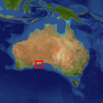
Australia is a large island. The entire transcontinental trip from Sydney to Perth takes a good four and a half days by road, or three comfortable but solid days if you begin driving just from Adelaide in South Australia. A little west of the Nullabor is the longest straight stretch of bitumen in the world. The road has been fully sealed since the mid 1970s, and runs close to the 100m cliffs of the Southern Ocean near the Western Australia / South Australia border. There once was a settlement called Eucla nearby: All that remains now are a few pylons and planks of the old wharf from where they used to ship camels, and the chimney of the old overland telegraph station, the rest of the building buried in the shifting sands.
You don’t have to drive, of course. One of the great remaining rail journeys of the world is undoubtedly the Indian-Pacific. The railway line runs a hundred kilometres north of the road over the Nullabor, and traverses a much drier part of the country.
There’s not much in the way of civilization to be found between Adelaide and Perth on the trip by road. Except a lonesome clavichord…
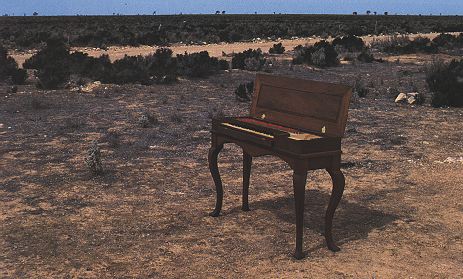 CAREY BEEBE 1992 |
Triple-fretted Clavichord, Carey Beebe • MCMXC |
| Projects index | |
| Clavichord Bibliography | |
| The Clavichord | |
| Site overview | |
| Harpsichords Australia Home Page |